Where the E10 Actually Stops
The E10 runs the length of the Lofoten archipelago, threading Austvågøya, Vestvågøya, Flakstadøya and finally Moskenesøya on bridges and through tunnels. Å i Lofoten is where the road simply stops. There’s no further village beyond it, no continuation to another island by car — only the sea, and beyond it the outer islands of Værøy and Røst, which you reach by boat or plane rather than by driving.
That dead-end position is the whole point of visiting. Å has not been bypassed by a newer, faster route the way some villages further up the archipelago have been; the E10 was built to end here, and the village grew up around a harbor that has been used for centuries. It is small enough to see on foot in an afternoon, and its size is part of why the fishing village museum works as well as it does — nothing here has needed to expand to accommodate scale.
A Village Built on Dried Fish
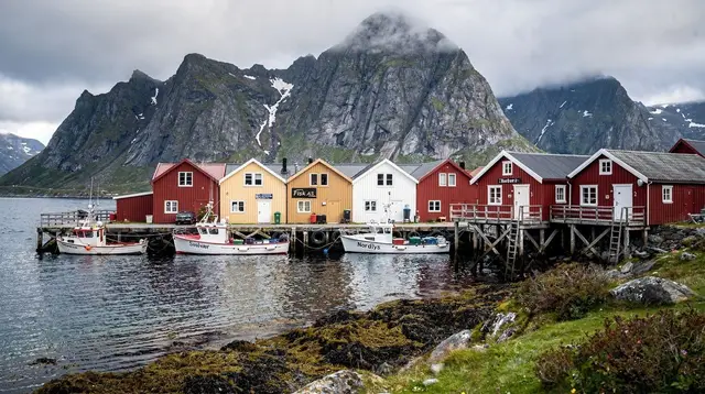
The buildings that make up much of Å today are the same ones that made it a working fishing station: boathouses, a bakery, workers’ cabins, and racks (hjell) once used to dry cod caught during the skrei season, which runs from January to April. Cod dried this way becomes stockfish (tørrfisk), a product Lofoten has exported for centuries, and Å is one of the more complete places to see the physical infrastructure of that trade still standing rather than reconstructed for effect.
Walking the harbor, you’ll see how tightly the buildings sit against the water — there was never much flat ground here to spare. The scale of the place says something honest about what a 19th- and early-20th-century Lofoten fishing station actually looked like: cramped, functional, and entirely organized around the rhythm of the cod season. If you want the fuller story of how stockfish shaped the economy of these islands, it’s covered in more depth in our guide to stockfish and the skrei season.
The Museum and What It Covers
The fishing village museum at Å occupies several of the original buildings and focuses on the everyday mechanics of the trade: how fish were split and hung, what a fisherman’s living quarters looked like, and how the export side of the business worked once the fish had dried. It’s a self-guided walk more than a formal tour, and it rewards slowing down rather than rushing through — reading the information in each building rather than treating it as a photo backdrop. Alongside the fishing history, there’s a small bakery still producing bread using older methods, which is as much a working piece of the site as it is a shop.
None of this is dressed up as adventure tourism, and that’s worth knowing before you arrive: this is a heritage stop, not an activity hub. If you’re looking for the more physical side of the region — kayaking the fjords, hiking, boat trips — those are based further up the archipelago, particularly around Reine and Hamnøy.
What the Season You Visit In Actually Changes
Å is small enough that the museum and harbor work in any month, but what you notice changes a lot depending on when you show up. During the skrei season, from January to April, the drying racks are loaded with cod and the smell of the fish is part of the experience rather than something you have to imagine from empty hjell. Outside those months the racks stand bare, and the village reads more as a preserved shell of the trade than as a place where it’s actively happening — still worth the stop, just a different kind of stop.
Summer brings long light this far south too, and by the weeks around the midnight sun the harbor stays lit well into what would otherwise be evening, which matters if you’re arriving late after a full day further north on Moskenesøya. Winter cuts the other way: daylight is short, so a visit needs to be timed into whatever window of light the day actually has rather than scheduled loosely for “afternoon.” On a clear winter night, the lack of any real village lighting at the end of the road also makes Å one of the less obstructed places on southern Moskenesøya to watch for aurora, though a clear sky matters as much as the season.
None of this is scheduled to a fixed calendar, because the one constant fact about weather here is that it changes fast — often within an hour. A grey, low-cloud morning can clear by midday, and a calm afternoon can turn to wind and rain with little warning. At the literal end of a dead-end road, with no town to retreat into, that matters more than it would somewhere with more shelter: build slack into the plan rather than assuming the conditions you see on arrival will hold for the whole visit.
What to Bring for the Walk
Because Å sits at the exposed end of the road, with open water on more than one side, it’s worth dressing for the harbor walk the way you’d dress for any coastal stretch in this region rather than for a museum visit. A windproof outer layer earns its keep here even on days that start calm, given how quickly conditions can turn. Good footwear matters too — the ground between the museum buildings and along the harbor edge is uneven in places, wet underfoot after rain, and there’s no indoor space to wait out a squall beyond the museum buildings themselves.
None of this is unique to Å, but it applies here with less margin for error than in a village with more shelter and more places to duck into. If you’re planning to walk beyond the immediate harbor toward the point, checking the sky before you set out is worth the minute it takes — there’s nothing between you and the open water once you’re past the last building.
What You’ll Miss If You Just Stop for the Sign
A common way to under-visit Å is to stop only for a photo at the road sign marking the end of the E10, then turn around. That skips almost everything the village actually offers. The museum buildings themselves need to be entered, not just photographed from outside — the point of the site is the detail inside each one: how the drying racks were rigged, what a fisherman’s cabin held, how the export side of the stockfish trade was organized once the fish had dried. Walking past the entrance without going in leaves you with a picture of red buildings and not much else.
The working bakery is easy to miss entirely if you don’t know to look for it, since it isn’t set up as a headline attraction — it’s a functioning part of the site rather than a gift shop. It’s worth building in the extra few minutes to find it. Beyond the museum cluster, the harbor itself continues past the main buildings toward the water, and a short walk along that stretch gives a better sense of how exposed the site is to the open sea than anything visible from the car park.
If time is genuinely short, the two things worth prioritizing over everything else are the museum interiors and the bakery — the outbuildings on the edges of the site add detail but not a fundamentally different picture, so they’re the first thing to cut if you’re working with less than an hour.
Beyond Å: Moskstraumen and the Open Water
South and west of Å, the water opens toward the Moskstraumen, the maelström described by Edgar Allan Poe and Jules Verne — a genuinely strong tidal current running between the islands and the open sea, rather than the vortex of fiction. From land, you won’t see a dramatic whirlpool, but you will get a sense of how exposed this stretch of coast is, with the sheltered fjords of the inner islands giving way to open water. Værøy and Røst, both known for seabird colonies including puffins, sit further out and are reached by ferry or a short flight rather than the road network that ends at Å.
For most visitors, Å is a place to look outward from rather than a base for exploring further — there isn’t the infrastructure here that you’ll find in Reine or Moskenes, and lodging options thin out considerably this far along the E10.
Getting Here and Getting Back
Å sits past Reine, Hamnøy, Sakrisøy and Moskenes on the E10, so unless you’re staying nearby, plan for a there-and-back drive from wherever you’re based. If your route includes the ferry to Bodø, Moskenes — a few minutes back up the road — is the departure point, and it’s worth checking our guide to the Bodø–Moskenes ferry before you finalize timing, since the crossing runs on a schedule that shapes the rest of a Moskenesøya day.
Public transport reaches Å, but infrequently; a rental car remains the most practical way to combine it with the rest of southern Moskenesøya in a single day. If you’re hiking Reinebringen or the trail to Kvalvika Beach the same day, budget realistically — the stone staircase up Reinebringen alone takes real time and effort, and Å is easy to under-schedule for once you’ve already spent a morning on a trail.
In winter, the E10 itself is maintained and bridges and tunnels keep the route open, but conditions on the exposed final stretch past Moskenes can turn icy or windy with little notice, in keeping with how fast the weather here shifts. Driving cautiously and leaving margin to turn back or wait out a squall matters more on this last leg than it does further up the archipelago, where there’s more shelter and more places to stop.
Filling Out the Day With an Activity Nearby
Å itself isn’t an activity base — there’s nowhere here to book a boat or a hike — so anyone wanting more than the museum and harbor needs to build that into the rest of the day, based further north on Moskenesøya. Reine and Hamnøy, both a short drive back along the E10, are where most of that is organized. A guided kayak trip on Reinefjord pairs naturally with an Å visit for anyone staying near Reine, since it works the same body of water from a different angle than the road does.
For winter visits, a guided snowshoe hike between the fjords and summits is a way to get above the villages rather than only driving between them, on the days when the museum alone doesn’t fill the light you have. And if the evening after an Å stop is clear, a guided northern lights tour departing from Svolvær is worth planning around for travelers based further up the archipelago — it needs a dark, clear sky rather than any particular location, so it isn’t tied to being at Å itself, but it’s a reasonable way to close out a long day that started at the end of the road.
How Å Fits Into a Longer Lofoten Trip
| If you have… | Å i Lofoten fits as… |
|---|---|
| A half-day in southern Moskenesøya | The natural final stop after Reine and Hamnøy |
| A full Lofoten road trip | The literal end point — turn around here |
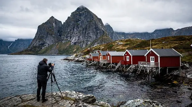
| A photography-focused visit | A quieter, less-photographed harbor than Reine |
| A tight schedule | Skippable in favor of Reinebringen or Nusfjord |
Å pairs naturally with a broader 3-day Lofoten itinerary or a hiking-focused trip like our 6-day hiking itinerary, both of which have room for a detour this far south without derailing the rest of the plan.
Frequently Asked Questions About Å i Lofoten
Is Å i Lofoten worth the drive to the end of the E10?
If you’re already touring Moskenesøya and have seen Reine and Hamnøy, yes — it’s a short additional drive and gives a more complete picture of the fishing-village economy than the more photographed villages further north. If time is very tight, it’s the first thing to cut.
How long does it take to see Å i Lofoten?
Most visitors need one to two hours for the museum and harbor. Add extra time if you also want to walk further along the coast or combine the stop with lunch.
Is there anywhere to stay in Å?
Lodging options exist but are limited compared with Reine or Moskenes, both a short drive back up the E10. Many visitors base themselves further north and treat Å as a day stop.
Does Å i Lofoten have facilities like shops or fuel?
Facilities are minimal — this is a small village at the end of a road, not a service town. Fuel up and stock up in Reine or Moskenes before continuing.
Can I combine Å with the Moskenes ferry to Bodø?
Yes — Moskenes, the ferry port, is only a few minutes back along the E10 from Å, which makes it easy to fit a short visit in before or after a crossing. See our ferry guide for timing.
What’s the difference between Å and Reine?
Reine is larger, more developed for tourism, and the base for most boat trips and photography stops on Moskenesøya. Å is smaller, quieter, and built specifically around its fishing-village museum rather than a range of activities.
Is the stockfish smell noticeable in Å?
During and after the skrei season, the smell of drying cod is part of the experience at any working stockfish site in Lofoten, Å included. It fades outside the main drying months but the racks themselves remain visible year-round.