A staircase built for a view, not for comfort
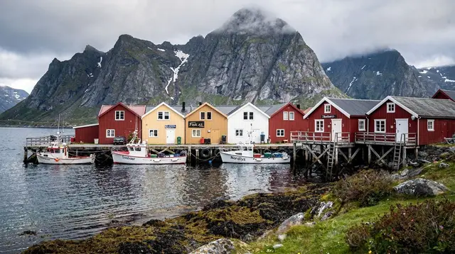
Reinebringen is a mountain on Moskenesøya, the peak that rises directly behind Reine and produces the view most people already have in their head before they ever reach Lofoten: a cluster of red and white houses on a narrow spit of land, ringed by sharp granite peaks and open water. The path to that view is a stone staircase of roughly 1,566 steps, built between 2016 and 2019 by Sherpa work crews using the same dry-stone technique used on trails in Nepal. It replaced a route that used to be a scramble of loose scree and social trails, worn raw by a viewpoint that was already famous before there was a proper way up to it.
The staircase does its job well. It stops erosion, it gives boots something solid to land on, and it turns what used to be a genuinely risky scramble into a defined, if strenuous, hike. What it does not do is make the climb easy. The steps are uneven in height and depth — that is a deliberate feature of the sherpa-style construction, not a flaw — and there is very little flat ground between the trailhead and the summit ridge. This page covers what the climb actually asks of you, hour by hour, and when the answer to “should I do this today” is no.
The climb, step by step
The trailhead sits just off the E10 on the edge of Reine, at a small parking area that fills up fast on clear summer mornings. From there the staircase begins almost immediately — there is no warm-up flat section, which surprises people who assume a staircase eases you in.
The first third of the climb is the steepest and, for most visitors, the hardest part psychologically: the steps rise in tight switchbacks with the village and fjord already visible below, which tends to make people stop constantly to look back and take photos, adding time without covering ground. The middle section eases slightly in gradient but keeps climbing steadily, weaving between exposed rock slabs and patches of low vegetation. The final approach to the summit ridge is narrower and rockier, with the stonework giving way to a natural path over bedrock for the last stretch.
Total elevation gain is around 450 metres over roughly 1.8 kilometres one way, which is a genuinely steep average gradient for a maintained trail. Fit, regular hikers typically go up in 45 minutes to an hour and take a similar time coming down, plus time at the top — realistic round-trip planning is 2.5 to 4 hours including a rest at the summit, longer if you’re stopping often for photos or if the ground is wet.
Descending is where most problems happen. The steps are uneven and can be slick after rain, and tired legs on a steep downhill staircase are a common source of slips and twisted ankles. Trekking poles help more here than on almost any other trail on the island, precisely because the terrain doesn’t let your stride settle into a rhythm.
Why the staircase looks the way it does
The dry-stone technique used here is the same method used on popular trekking routes in Nepal, brought to Lofoten specifically because it holds up under heavy foot traffic without the erosion scarring that a dirt path would show within a few seasons. Stones are fitted and packed by hand rather than poured or bolted, which is why the risers vary in height from one step to the next — each stone was set according to the shape of the ground beneath it, not to a uniform blueprint. That variability is the trade-off for durability: it’s part of why the climb feels more tiring underfoot than a staircase of consistent steps would, even though the total elevation gain is fixed regardless of how the steps are shaped.
Before the staircase existed, the same route was a bare scramble over loose scree and exposed rock, worn into a scar of eroding trail by a viewpoint that had already become popular by word of mouth and photography long before there was any managed way up to it. The construction project addressed that erosion problem directly, and it succeeded — but it didn’t, and was never going to, turn the mountain into an easy walk. It made a genuinely difficult route safer and more sustainable, not gentler.
Timing the climb for light and crowds
Because the payoff here is entirely visual, when you climb matters almost as much as whether you climb at all. During the midnight sun weeks, there’s no fixed daylight window forcing an early start, which spreads visitor traffic out unevenly — the two or three hours around what would normally be sunrise and sunset still draw the most photographers, since the low, raking light picks out Reine’s rooftops and the surrounding ridgelines more dramatically than the flatter light of midday. Outside midsummer, a normal early-morning start avoids both the worst of the crowds and the buildup of afternoon cloud that can roll in off the sea later in the day.
Midday in peak summer is when the trailhead parking area is busiest and the summit ridge most crowded, which doesn’t affect the difficulty of the climb but does affect how much room there is to sit and take in the view once you’re up there. If your schedule allows flexibility, an evening climb during the lighter months tends to reward patience with both a thinner crowd and better light than a rushed midday attempt squeezed between other stops.
Who this hike suits, and who it doesn’t
Reinebringen isn’t a technical climb — there’s no exposure requiring hands-on scrambling if you stay on the steps — but it is a serious cardiovascular and leg-strength test packed into a short distance. Anyone with a reasonable level of hiking fitness who has done a steep staircase or steep trail before will manage it. It is not a good match for anyone with knee problems that flare up on descents, for young children who tire on sustained climbs, or for visitors expecting a casual walk because the distance on a map looks short.
a guided snowshoe route through the wider Reine area is a reasonable substitute when the staircase itself is closed or icy, since it covers similar terrain at a gentler, guide-set pace and with the right equipment for snow.
For a broader sense of how this hike compares to other options on the islands, see the best hikes in Lofoten and the general hiking safety notes, which apply here more than almost anywhere else on the archipelago given how exposed the staircase is to wind.
Weather, conditions, and when the staircase is closed
The single most important practical fact about Reinebringen is that it is frequently closed, and the closures are not arbitrary. The trail is shut during periods of snow and ice cover, typically from some point in autumn through late spring, because the stone steps become a genuine fall hazard once frozen or snow-packed — the same uneven risers that make the trail manageable in summer turn treacherous underfoot. Exact opening and closing dates shift year to year with the weather, so the only reliable approach is to check current signage and local conditions when you arrive rather than assuming a hike done in July will still be open in October.
Even within the open season, the weather in Lofoten can change within the hour you’re climbing. A clear morning at the trailhead is no guarantee of a clear summit — cloud can roll in off the sea and swallow the exact view you climbed for, and wind at the exposed summit ridge is consistently stronger than at the base. Rain turns the stone steps slick almost immediately, and descending a wet staircase built from irregular stone is meaningfully harder than descending it dry. If the forecast shows heavy rain or strong wind, this is a hike to postpone rather than push through — the reward is entirely dependent on visibility, and there is no partial credit for a climb into cloud.
Midsummer brings its own version of a planning problem: the midnight sun means there’s no hard cutoff forcing an early start, but it also means the viewpoint is busiest in the hours photographers consider “golden,” typically early morning or late evening when the low sun rakes across Reine and the fjord.
Getting there and parking
The trailhead is on the edge of Reine, reachable by car along the E10 from any base on Austvågøya or Vestvågøya, or on foot if you’re already staying in Reine, Hamnøy, or Sakrisøy. Parking near the trailhead is limited and fills early on clear summer days — arriving before mid-morning materially improves your odds of a spot, and arriving in the evening for a midnight-sun climb usually means an easier time finding one.
If you don’t have a car, getting to Reine from Moskenes or points further along the E10 requires either local bus service or a taxi, since the trailhead itself isn’t served directly by long-distance transport. For a rental-car comparison against guided transport for this whole part of the island, guided tours versus self-drive covers the trade-offs in more depth.
What you see from the top, and what the cloud takes away
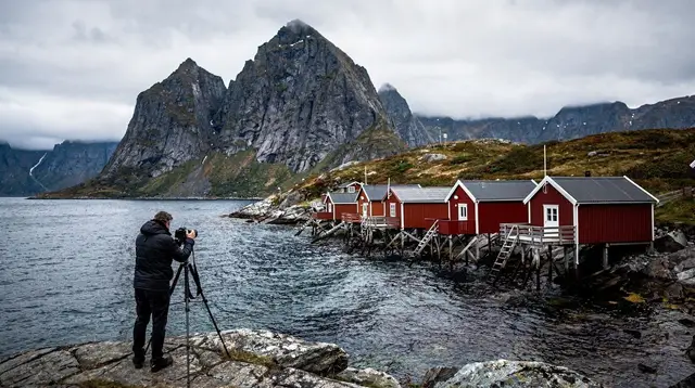
On a clear day, the summit ridge delivers the view Reinebringen is known for: Reine’s cluster of rorbuer and houses laid out on its spit of land, the fjord split into channels around it, and the jagged wall of peaks — Olstinden among them — rising directly behind the village. Beyond Reine, on a good day, the eye follows the coastline further along the fjord’s edge toward Å i Lofoten and the open sea past Moskenes, the direction of the Moskstraumen maelström that gave this stretch of coast its old reputation.
What you don’t get on a cloudy day is any of that. Fog at the summit doesn’t lower the difficulty of the climb — you still gain the same 450 metres — but it removes the entire payoff, since the view is the reason the trail exists. This is worth repeating because it’s the most common disappointment reported by hikers who climb on a day when the forecast at sea level looked fine but the summit itself sat in cloud, which happens more often here than the base-of-trail weather would suggest.
For photographers specifically planning around this exact view, photo spots around Reine and Hamnøy covers vantage points that don’t require the climb, useful as a backup plan or a complement to the Reinebringen shot.
Combining Reinebringen with the rest of Moskenesøya
Most visitors treat Reinebringen as a half-day activity rather than a full day, which leaves time to also see Hamnøy’s photogenic rorbuer, wander Sakrisøy’s small fishing hamlet, or drive on to the fishing-village museum at Å i Lofoten where the E10 ends. If you have the light and the legs for it after the descent, a slow evening drive to the end of the road and back is a natural pairing.
For travellers with a bit more time and clear evening skies, some choose to add a paddle out onto Reinefjord itself during the summer months, which gives a sea-level counterpoint to the aerial view from the staircase — the same fjord and mountains, seen from the water rather than from 450 metres above it. Outside the midnight sun window, when nights are dark again, a guided aurora hunt departing from Svolvær is a common way to fill the evenings once daytime hiking options like Reinebringen close for the season.
If you’re building a longer stay around this part of the island, a five-day itinerary includes Moskenesøya as a base, and how many days you actually need in Lofoten discusses how much of the archipelago is realistic to combine with a hike like this one. A three-day itinerary and general accommodation and car-rental planning are worth reading before you arrive, ideally well before you’re standing at the trailhead deciding when to start.
Reinebringen: questions before you climb
Do I need hiking boots for Reinebringen?
Sturdy footwear with real grip is strongly recommended. The stone steps are uneven and can be wet or covered in loose grit, and trainers with worn soles are a common cause of slips on the descent.
Is Reinebringen suitable for children?
It depends entirely on the child’s fitness and stamina for a sustained, steep climb — there’s no technical difficulty, but the 450-metre gain in under two kilometres is demanding, and there’s no shortcut partway up if a child tires out.
Can I do Reinebringen in winter?
Generally no. The staircase is closed for extended periods when snow and ice make the steps hazardous; if you’re visiting outside the summer season, check current local conditions rather than assuming the trail is open, and consider a guided snowshoe alternative instead.
How crowded does the trail get?
It’s one of the more visited hikes on the islands during the open summer season, especially in the two or three hours around sunrise and sunset when the light on Reine is best. Midday is usually quieter for the climb itself, though the view can still be hazy.
Is there an entry fee for Reinebringen?
There’s no fee to walk the staircase itself; the cost, such as it is, is the parking situation near the trailhead in Reine during peak hours.
What should I bring on the climb?
Water, layers for wind at the exposed summit, and trekking poles if your knees don’t love steep descents. Given how fast Lofoten’s weather can turn, a waterproof shell is worth carrying even under a clear morning sky.
How does Reinebringen compare to other Lofoten hikes?
It’s shorter in distance but steeper and more sustained than most alternatives; for context against other trails on the islands, see the best hikes in Lofoten guide.
Is the view really worth the climb?
On a clear day, most hikers who’ve done other viewpoints on the islands rank this among the best — but the view depends entirely on the summit being cloud-free, which isn’t guaranteed even when the base of the trail looks clear.