Easy Walks in Lofoten: Short Trails for Rainy Days and Families
What are the best easy walks in Lofoten for families or a bad-weather day?
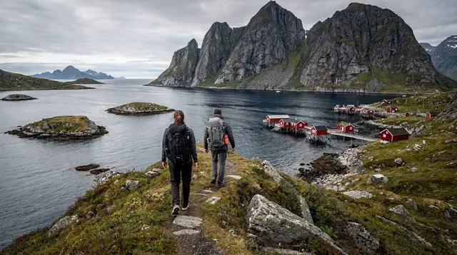
The flattest, shortest options are around Haukland and Uttakleiv beaches, the harbour boardwalks of Henningsvær and Kabelvåg, and the low shoreline paths near Reine. Most take under two hours round trip on established paths, with no scrambling and no exposure — a fallback when wind or rain rules out the higher ridge hikes.
When the ridge hikes are off the table
Lofoten’s reputation is built on its hard hikes — the stone staircase up to Reinebringen, the exposed traverse to Ryten above Kvalvika beach. Both are worth the effort in good conditions, and both are miserable, occasionally dangerous, in bad ones. Wind on an open ridge does not behave like wind at sea level, and a forecast that looked fine at breakfast can turn by mid-morning — the single most practical fact about this archipelago’s weather.
That leaves a real gap for anyone travelling with young children, recovering from an injury, or simply arriving on a day when the cloud sits on the peaks. This guide covers the other side of Lofoten’s hiking scene: routes that stay close to sea level, follow established paths or boardwalks, and can be shortened or turned around at almost any point without losing the point of the walk. None of them require a rope, a guide, or specialist gear, though the general hiking safety guidance for Lofoten still applies — flat does not mean risk-free once wind and cold enter the picture.
If you’d rather have someone else handle the pace, the route-finding and the flask of something hot, an easy guided winter hike with lunch included covers the same territory with none of the planning.
Austvågøya: boardwalks, harbours and a coastal headland
The island holding Svolvær also holds some of the flattest walking in the archipelago, mostly because so much of it threads between fishing villages rather than up mountainsides.
Henningsvær is the standout for an easy outing. The village itself is scattered across a handful of islets connected by short bridges and causeways, and simply wandering its lanes — past the harbour, alongside the football pitch wedged between the rock and the sea — makes for a walk of an hour or two with no elevation gain at all. From the edge of the settlement, a level path continues a short way along the shoreline before the terrain steepens toward the peaks behind the village; turning back at that point keeps the outing firmly in easy territory.
Kabelvåg, the region’s oldest town, offers a similar low-effort wander around its harbour and past its large wooden church, with views out toward Skrova and the open water beyond. It’s a walk better measured in minutes than hours, but it pairs naturally with a stop at Svolvær on the same day, and it holds up regardless of what the wind is doing.
Further out toward Eggum, on the island’s exposed north-western coast, short paths run along the dune line behind the beach. These are flat but genuinely windswept — a good pick on a still day, a poor one when a gale is forecast.
Vestvågøya: sand, dunes, and a Viking longhouse
Vestvågøya carries two of the archipelago’s most photographed beaches, and both come with easy walking built in. Haukland and Uttakleiv sit close enough together that a single visit can combine a stroll along Haukland’s sand with the short path over the low headland connecting it to Uttakleiv’s rockier shore. Neither beach demands more than comfortable shoes, and the connecting path, while uneven underfoot in places, involves no real climbing.
Inland, the reconstructed Iron Age longhouse at the Lofotr Viking Museum near Borg sits in flat farmland, and the grounds around it make for an easy, largely level walk that works regardless of the weather — useful to know on a day when the coast is being battered by wind and the museum’s indoor exhibits offer a fallback anyway.
Unstad, better known for its surf than its hiking, also has a short shoreline stretch that can be walked without any real gradient, though the main draw there is watching the waves rather than covering distance.
Flakstadøya and Moskenesøya: shoreline routes near the fishing villages
Ramberg, on Flakstadøya, has a long sand beach running directly alongside the E10, which makes it one of the easiest walks in the entire archipelago to reach and to shorten — park, walk as far as you like, turn back. It’s a reasonable substitute for Haukland on a day when that beach’s car park is full or the weather has pushed everyone toward the more sheltered option.
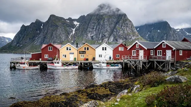
Moving south toward Moskenesøya, the villages of Reine, Hamnøy and Sakrisøy sit close together along the fjord, and the low road and path network connecting them makes for an easy, scenic walk with the option to stop at any of the three. This is flatter and more forgiving than almost anything else on the island, and it puts you in the same landscape that draws photographers up Reinebringen, without the staircase. At the far end of the E10, Å i Lofoten has a short walk around its preserved fishing village that covers a similar amount of ground.
None of this is Nusfjord, Kvalvika or Reinebringen territory — those stay in the harder category covered elsewhere in Lofoten’s best hikes — but for a half-day on foot with a buggy-aged child or a knee that isn’t up to stone steps, this stretch of coast delivers more scenery per step of effort than almost anywhere else in the islands.
For a broader loop that strings several of these villages together with a guide handling the driving, a road trip through Reine and Å covers this same ground without you needing to plan the stops yourself.
Further north: easy walking in Vesterålen
For visitors extending a trip beyond the main Lofoten chain, Vesterålen offers its own set of low-effort coastal walks that pair naturally with a longer stay. Sortland, known locally as the blue town for the murals along its waterfront, has a flat harbourside walk that takes in the bridge and the town’s compact centre without any real elevation change. Further out toward Andenes, at the tip of Andøya, short paths run along the shoreline near the whale-watching harbour, flat enough to combine with a boat trip departure without adding meaningfully to the day’s exertion. Nearby Bleik, with its long beach, offers the same kind of flexible, walk-as-far-as-you-like stretch of sand as Ramberg does further south.
The outer coast around Nyksund and Stø trades some of that flatness for more exposed, weather-beaten walking among a scatter of buildings and open coastline, worth treating with the same caution as Eggum on a windy day. Stokmarknes, home to the express coastal ferry’s museum, adds an easy, largely indoor fallback for a day when the weather rules out coastal walking entirely. None of this requires a separate packing list from the rest of this guide — the same waterproof layers and grip-soled footwear that work in Lofoten proper cover Vesterålen just as well.
Comparing the routes
| Walk | Island | Approx. distance | Approx. time | Terrain |
|---|---|---|---|---|
| Henningsvær village loop | Austvågøya | 2–4 km | 1–2 h | Flat lanes, causeways |
| Kabelvåg harbour walk | Austvågøya | 1–2 km | 30–60 min | Flat, paved and gravel |
| Haukland–Uttakleiv link | Vestvågøya | 3–5 km | 1–2 h | Sand, low headland path |
| Borg Viking Museum grounds | Vestvågøya | 1–3 km | 30–90 min | Flat farmland |
| Ramberg beach | Flakstadøya | Flexible | 30 min–2 h | Sand, roadside access |
| Reine–Hamnøy–Sakrisøy | Moskenesøya | 3–6 km | 1.5–2.5 h | Flat road and path |
| Å i Lofoten village walk | Moskenesøya | 1–2 km | 30–60 min | Flat, gravel and boardwalk |
These figures are approximate and depend on how far each walk is extended — every one of them can be shortened to a fifteen-minute stroll or lengthened by continuing along the coast before the terrain steepens.
Packing for a short walk in changeable weather
The distances here are modest, but the same rule that governs every outdoor plan in Lofoten still applies: conditions can shift within an hour, regardless of season. A few basics make the difference between a pleasant walk and a miserable one:
- A waterproof outer layer, even when the forecast looks clear at the start.
- Footwear with grip — trainers handle dry boardwalk fine but struggle on wet rock or icy ground outside the summer months.
- A headlamp outside the midnight sun window, since daylight runs short for much of the year and none of these paths are lit.
- Layers rather than one heavy coat — walking generates heat quickly even on a flat path, and the wind off the water cools you down just as fast once you stop moving.
None of this is specialist mountain kit; it’s the same short packing list worth keeping in the car for any family day out in Lofoten, whether the plan is a beach walk or a museum visit with a walk tacked on. For anyone assembling a longer kit list before the trip, the general Lofoten packing guide covers it in more depth, and the weather guide explains why the forecast is worth checking again the morning of, not just the week before.
If getting between these villages without renting a car is the sticking point, the guide to getting around Lofoten lays out the bus and ferry options along the E10 corridor that most of these walks sit on.
How the season changes an easy walk
The word “easy” describes terrain, not conditions, and the same flat path behaves very differently depending on the time of year. Through the midnight sun weeks, roughly late May to mid-July, there’s effectively no daylight constraint at all — a walk can be taken at any hour, which is particularly useful with young children whose nap schedules rarely align neatly with a day’s sightseeing plan. Summer temperatures, typically 12 to 17°C, also mean these walks work comfortably without the heavier layers winter demands, though a windproof shell is still worth carrying on the more exposed stretches like Eggum or the Vesterålen outer coast.
Outside summer, and especially near the polar night from early December to early January, the same walks need to be timed around a much shorter daylight window, and a headlamp stops being optional gear and becomes something to actually plan around. Winter air temperatures, generally 0 to −3°C thanks to the Gulf Stream, are milder than the latitude suggests, but ice on boardwalks and packed snow on gravel paths change footing even on routes with no real elevation gain. None of the walks in this guide become technical in winter, but “easy” in January means something different underfoot than “easy” in July, and it’s worth adjusting footwear and pace expectations accordingly rather than assuming a flat summer route stays exactly as effortless once the season turns.
Building an easy-walk day around a guided tour
Several of the bookable tours covering this region are built around exactly this kind of pace. A guided hike in the Lofoten Islands, run in French keeps a gentler tempo than the technical routes and works well for a mixed group. For a single day that moves between villages rather than up a mountainside, a day trip covering Lofoten’s highlights from Reine combines several of the stops above — Reine, Hamnøy, the coast road — into one outing with a driver and guide, which removes the logistics entirely on a day when the weather makes independent route-planning more trouble than it’s worth.
For hikers who do want more elevation once conditions improve, the category page for hiking trails and the snowshoeing guide for the winter months cover the next step up, and a five-day family itinerary shows how these easier walks slot into a longer trip alongside museum visits and boat trips.
Easy walks in Lofoten: your questions answered
Are there hikes in Lofoten that don’t require good weather?
Some, but be realistic: low coastal paths and boardwalks are far less exposed to wind than ridgelines, and they stay walkable in drizzle. Heavy rain, ice, or gale-force wind can still close even the easiest route, since Lofoten’s weather changes within the hour.
Can small children walk these trails?
Most of the routes described here are on flat or gently sloping ground with no cliff edges, which makes them workable with young children — though a buggy will still struggle on sand or uneven boardwalk sections, so a child carrier is more practical than a pushchair.
Is Reinebringen an easy walk?
No. Reinebringen is a stone staircase of 1,566 steps built by Nepalese sherpas, and it belongs in a different category entirely — treat it as a serious, sustained climb, not a stroll.
What should I bring on a short Lofoten walk?
Waterproof layers regardless of the forecast, sturdy shoes rather than sneakers, and a headlamp outside the midnight sun months, since daylight is short in autumn and winter and paths have no lighting.
Are these walks open in winter?
Some sections ice over and are better with proper footwear traction, and a few beach paths get exposed to salt spray and wind in storms. None of the routes here require snowshoes, but conditions vary week to week, so check locally before setting out.
Do any of these walks have facilities nearby?
Several pass through or near villages such as Henningsvær, Kabelvåg and Reine, where cafés and shops exist, but this guide does not list specific businesses — check locally on arrival.
Hiking tours on GetYourGuide
Verified deep-linked GetYourGuide tours. Book through these links and we earn a small commission at no cost to you.
Photos show the destination, not the operator's own images.