The Ryten and Kvalvika Hike: Fredvang's Signature Loop
How long does the Ryten and Kvalvika hike take?
Most walkers need several hours round trip from Fredvang, combining the walk to Kvalvika Beach with the climb up Ryten. Actual time depends heavily on fitness, weather, and how long you linger at the top.
Why This Loop Gets Named So Often
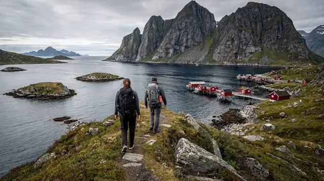
Ask around for the single hike people mention most from a Lofoten trip, and the Kvalvika-Ryten loop from Fredvang comes up constantly. Two things drive that reputation: Kvalvika Beach itself, reachable only on foot, and the summit of Ryten above it, which delivers a view straight down over the bay that’s become one of the archipelago’s most recognizable images. Neither element alone would draw quite the same attention — plenty of Lofoten beaches have road access, and plenty of summits have good views — but the combination of an inaccessible beach and a summit looking directly onto it is what makes this particular walk stand out.
The trailhead sits at Fredvang, on Flakstadøya, reached by road from the E10. From there, the walk to the beach and the climb up Ryten can be done as one continuous outing or split, depending on how much time and energy you’re bringing to the day.
The Route, Step by Step
From the Fredvang car park, the path to Kvalvika Beach crosses a mix of open ground and boggy sections before descending to the sand. This stretch alone is a worthwhile walk even without continuing up to Ryten, and some visitors do treat it as a standalone destination — see our best beaches in Lofoten guide for how Kvalvika compares to the archipelago’s road-accessible beaches.
From the beach, the path up Ryten climbs steadily, gaining height quickly enough that the effort is felt well before the top. The terrain shifts from grass to rock as you climb, and the final stretch requires care rather than technical climbing skill — hands-on-rock scrambling in a few short sections, not exposed climbing. At the top, the payoff is immediate: Kvalvika Beach directly below, framed by the surrounding peaks, with the open sea beyond.
| Section | What to expect |
|---|---|
| Fredvang to Kvalvika Beach | Boggy ground in places, a moderate descent to the sand |
| Kvalvika Beach to Ryten summit | The steepest section, loose rock and a scramble near the top |
| Ryten summit | The signature view, directly over the beach and out to sea |
| Return | Retrace the same route back to Fredvang |
What the Trail Actually Demands
This isn’t a technical climb, but it’s more demanding than its popularity might suggest. Wet ground is common given Lofoten’s coastal weather, and rock underfoot gets slick quickly once it rains — which, given how fast weather here can shift, is a real possibility even on a day that starts clear. Waterproof, sturdy footwear with real grip matters more on this trail than on most easier walks in the region; see our hiking safety in Lofoten guide for the broader precautions worth taking on any exposed trail here.
Fitness-wise, a reasonable level of hiking condition is enough — this isn’t a mountaineering objective — but the steep sections up Ryten will slow down anyone unused to sustained climbing. Budgeting more time than you think you’ll need, especially if photography is part of the plan, avoids the common mistake of getting caught by fading light on the descent.
When to Go
Summer’s long daylight hours, especially close to the midnight sun window from late May to mid-July, give the most flexibility for timing this hike — there’s little risk of running out of light, even on a slow day. That season is also when the trail sees the most foot traffic and the fullest car park at Fredvang. Shoulder seasons thin the crowds considerably but bring shorter daylight windows and a real chance of wetter, more slippery conditions underfoot. Winter conditions can add snow and ice to the upper sections, which changes the character of the hike substantially and isn’t something to attempt without appropriate experience and gear.
Whatever the season, checking the forecast before setting out is worth the five minutes it takes — conditions here can change within the hour, and a clear morning is no guarantee for the afternoon, particularly at exposed elevation near the summit.
Combining the Hike With the Rest of Flakstadøya
Fredvang sits close enough to Ramberg and Nusfjord that a hiking day can reasonably include a stop at one or both, particularly if you’re not exhausted after the climb. Ramberg’s own beach is road-accessible and makes an easy contrast to Kvalvika’s harder-earned sand, while Nusfjord’s preserved fishing village offers a completely different pace for the second half of the day. Our fishing villages of Lofoten guide covers Nusfjord and its neighbors in more detail if that’s part of your plan.
For travelers who’d rather see this stretch of coast without the physical demands of the hike itself, guided photo tours cover some of the same visual territory from accessible viewpoints and road stops. A 3-day Lofoten highlights photo tour bundles several of the archipelago’s best-known views into a structured itinerary, and a Lofoten Islands highlights day trip from Reine is a shorter option covering nearby ground.
Photography Notes
Ryten’s summit view is one of the most photographed in Lofoten for good reason: the composition essentially arranges itself, with the beach’s curve and the surrounding peaks doing most of the work. Morning light tends to be softer here than midday, and the midnight sun season extends the good-light window well into what would normally be night elsewhere. Our photography guide to Lofoten covers equipment and timing considerations relevant to a hike like this one, where you’ll be carrying gear over uneven terrain rather than shooting from a car park.
Safety Reminders Specific to This Trail
Beyond general hiking precautions, a few points apply specifically here. There’s no mobile signal guaranteed along the full route, so telling someone your planned return time before setting out is sensible. The scramble near Ryten’s summit has enough exposure that it’s not a place to push through in poor visibility or high wind — turning back is always an option, and the beach below is a worthwhile destination on its own if conditions don’t cooperate higher up. Bringing more water and food than feels strictly necessary is a small cost against the risk of the hike taking longer than planned, which happens more often than visitors expect on a trail that looks shorter on a map than it feels underfoot.
How This Compares to Lofoten’s Other Big Hike
The other trail every visitor asks about is Reinebringen, the stone staircase of 1,566 steps above Reine, built by Nepalese sherpas and finished with an entirely different kind of effort — a constructed staircase rather than a natural path. Our Reinebringen hike guide covers that trail in detail, but the short version of the comparison is this: Reinebringen is a shorter, steeper, more repetitive climb on stone steps with a view over Reine itself, while the Kvalvika-Ryten loop is a longer walk over varied terrain, ending with a scramble rather than steps, with a view over an inaccessible beach instead of a village. Neither replaces the other, and doing both across a longer stay gives a genuine sense of how different two of Lofoten’s signature hikes can be.
For a fuller list of options between these two, our best hikes in Lofoten guide ranks the region’s trails by difficulty and reward.
What to Pack for This Specific Trail
Beyond the general packing advice that applies to any Lofoten trip — covered in our packing guide — this hike rewards a few specific choices. Trekking poles help considerably on the steep, loose sections near the Ryten scramble, both climbing and descending. A change of socks left in the car is worth considering given how often the approach to Kvalvika crosses genuinely boggy ground. And because the weather here can shift within the hour, packing a waterproof shell even on a forecast that looks clear is a habit worth building before you’re caught out on an exposed summit with no shelter nearby. Our weather in Lofoten guide explains why the forecast here is less reliable at short range than most visitors expect.
If You’d Rather Not Do the Full Loop
Not every visitor wants or needs the full round trip. Walking only as far as Kvalvika Beach and skipping the climb up Ryten is a legitimate, shorter alternative that still delivers one of Lofoten’s better beaches without the steepest section of trail. Conversely, some hikers with less time but decent fitness push straight to the Ryten viewpoint and back without lingering on the beach itself. Either version cuts real time off the full loop, and knowing which parts matter most to you before setting out helps avoid over-committing on a day with limited daylight or deteriorating weather.
For a broader sense of how a hike like this fits into a longer stay, our 6-day hiking-focused Lofoten itinerary builds a full week around trails including this one, paired with rest days and easier walks in between.
Common Mistakes on This Trail
The most frequent misjudgment is underestimating the time required, particularly the climb up Ryten, which looks shorter on a map than it feels on tired legs after the walk in from Fredvang. A close second is starting too late in the day and getting caught by fading light on the return — a real risk outside the midnight sun months. Wearing inappropriate footwear for a trail this wet and uneven is the third common issue, and it’s the one most easily fixed before you leave home. Our mistakes to avoid in Lofoten guide covers these alongside other trip-wide pitfalls worth knowing about in advance.
If a fully guided alternative appeals more than navigating and pacing the hike yourself, a guided sightseeing and photo tour covering Lofoten’s road-accessible viewpoints is a lower-effort way to see comparable scenery without the climb, even if it can’t replace standing on Ryten’s summit itself.
Timing the Hike Within the Day
Beyond the seasonal timing already covered, the time of day you start matters more on this trail than on shorter, easier walks. Starting in the morning gives the most buffer if the hike takes longer than planned, and morning light on the climb up Ryten tends to be softer and less flat than the midday sun. During the midnight sun months, some hikers deliberately start later in the day specifically to be at the summit during the long, low-angled evening light, since darkness never really arrives to cut the day short. Outside that window, treat daylight as a hard constraint rather than a rough guide — turning back before dusk on a trail this exposed is always the safer call than pushing to finish in fading light.
Fredvang and the Approach
Fredvang itself is a small settlement rather than a destination in its own right, connected to the rest of Flakstadøya by a set of bridges off the E10. There’s little reason to linger here beyond using the car park as a base for the hike, though the drive in offers early views of the terrain you’re about to climb, which is a useful preview for gauging conditions before you’ve committed to the trail. Cell coverage can be patchy in and around Fredvang, so it’s worth downloading any maps or route information you might need before you arrive rather than relying on a live connection partway through the hike. Fuel up and use facilities before leaving Ramberg or Leknes if you’re coming from further afield, since Fredvang itself offers little beyond the trailhead.
Kvalvika and Ryten Hiking Questions
Is the Kvalvika-Ryten hike difficult?
It’s moderate rather than extreme, but the climb up Ryten is steep in places and the ground can be wet and uneven, which makes it harder than the distance alone suggests.
Can I drive to Kvalvika Beach?
No — Kvalvika is only reachable on foot, from Fredvang, which is part of what keeps it quieter than beaches with direct road access.
Do I need hiking boots for this trail?
Sturdy, waterproof footwear is strongly recommended. The path crosses boggy sections and loose rock, and standard sneakers struggle in wet conditions common to this coast.
Is the view from Ryten worth the climb?
It’s one of the more photographed viewpoints in Lofoten, looking directly down over Kvalvika Beach with the surrounding peaks framing the bay, which is why the hike draws as many visitors as it does.
What’s the best time of year for this hike?
Summer offers the longest daylight and driest ground, though the trail is popular then. Shoulder seasons are quieter but bring shorter days and a higher chance of wet or slippery conditions.
Is there parking at Fredvang?
A car park serves the trailhead at Fredvang, though it can fill on busy summer days, similar to other popular trailheads across Lofoten.
Hiking tours on GetYourGuide
Verified deep-linked GetYourGuide tours. Book through these links and we earn a small commission at no cost to you.
Photos show the destination, not the operator's own images.